Nadji na karti pa ces vidjeti
| banjalukaforum.com https://banjalukaforum.com/ |
|
| Aralsko jerzero gotovo presusilo https://banjalukaforum.com/viewtopic.php?f=55&t=49003 |
Stranica 1 od 1 |
| Autoru: | goci master [ 05 Apr 2010, 17:16 ] |
| Tema posta: | Aralsko jerzero gotovo presusilo |
Nekada cetvrto najvece jezero postalo gomila pijeska i soli. http://www.unmultimedia.org/radio/engli ... 93289.html |
|
| Autoru: | alkibijad [ 05 Apr 2010, 17:21 ] |
| Tema posta: | Re: Aralsko jerzero gotovo presusilo |
Ne kontam jel jezero il more? |
|
| Autoru: | goci master [ 05 Apr 2010, 17:25 ] |
| Tema posta: | Re: Aralsko jerzero gotovo presusilo |
Nadji na karti pa ces vidjeti |
|
| Autoru: | alkibijad [ 05 Apr 2010, 17:27 ] |
| Tema posta: | Re: Aralsko jerzero gotovo presusilo |
http://vukajlija.com/zabava/posteri/7304 |
|
| Autoru: | Hertzog [ 05 Apr 2010, 17:28 ] |
| Tema posta: | Re: Aralsko jerzero gotovo presusilo |
Nikako nisam mogao da nadjem vise satelitskih snimaka za usporedu, procitao sam da su te reke koje su snadbevali jezero vodom uglavnom preusmerene na obliznja polja pamuka tako da voda u malim kolicinama dlazi do jezera i zato je presusilo tako brzo |
|
| Autoru: | goci master [ 05 Apr 2010, 17:34 ] |
| Tema posta: | Re: Aralsko jerzero gotovo presusilo |
Evo super prikaz stanja jezera hronoloski, klikajte na godine od 2000-2009. Sta su sebi dozvolili, nevjerovatno. http://earthobservatory.nasa.gov/Featur ... al_sea.php |
|
| Autoru: | Hertzog [ 05 Apr 2010, 17:37 ] |
| Tema posta: | Re: Aralsko jerzero gotovo presusilo |
Interesantno da se celo jezero smanjilo a samo se ovaj gornji izdvojeni deo povecao izmedju 2000. i 2009. godine... A i najvise je presusilo u 2009. god |
|
| Autoru: | filozof sa vrbasa [ 05 Apr 2010, 18:29 ] |
| Tema posta: | Re: Aralsko jerzero gotovo presusilo |
Ovo ce biti 4. put da kupujem Atlas svijeta zbog promjene na planeti Zemlji. |
|
| Autoru: | skypostman [ 06 Apr 2010, 12:30 ] |
| Tema posta: | Re: Aralsko jerzero gotovo presusilo |
alkibijad je napisao: Ne kontam jel jezero il more? Језеро наравно. Занимљиво је то, јер је и ту политика тј гео-политика умјешена. Амери инсистирјау на статусу мора(свако море има међународне, тј слободне воде) јер би тада могли своје бродове инсталирати у Каспијском језеру, буквално на прагу Русије, а Руси наравно инсистирају на статусу језера јер је тако онемогућено управо упловљавање Америчких бродова... Што се тиче Аралског језера, као што Херц рече доток воде у језеро је знатно смањен јер се привреда бивших совјетских република преструктуирала, Совјети су 1960. извршили "скретање" тока ријека Аму-Дарја и Сир-Дарја ради наводњавања поља памука и тиме смањили доток воде у Аралско језеро. Данас се такође користе велике количине воде управо за наводњавање. Град Аралск је некада био лука, а данас је неколико километара удаљен од воде... |
|
| Autoru: | Hertzog [ 06 Apr 2010, 13:55 ] |
| Tema posta: | Re: Aralsko jerzero gotovo presusilo |
Prejaka je slika tog grada, kada odes na Google Earth i kada vidis dokove u pustinji i brodove okolo u pesku Neverovatna slika |
|
| Autoru: | laoce [ 09 Apr 2010, 17:07 ] |
| Tema posta: | Re: Aralsko jerzero gotovo presusilo |
Tacno tragedija, citao sam da vise nema ni ribe, jer je postalo preslano, a mnogi su tamo zivjeli i od ribolova, a sve zbog uzgoja pamuka. |
|
| Autoru: | skypostman [ 09 Apr 2010, 17:12 ] |
| Tema posta: | Re: Aralsko jerzero gotovo presusilo |
|
|
| Autoru: | filozof sa vrbasa [ 09 Apr 2010, 22:47 ] |
| Tema posta: | Re: Aralsko jerzero gotovo presusilo |
Jezivo. |
|
| Autoru: | skypostman [ 31 Okt 2010, 18:49 ] |
| Tema posta: | Re: Aralsko jerzero gotovo presusilo |
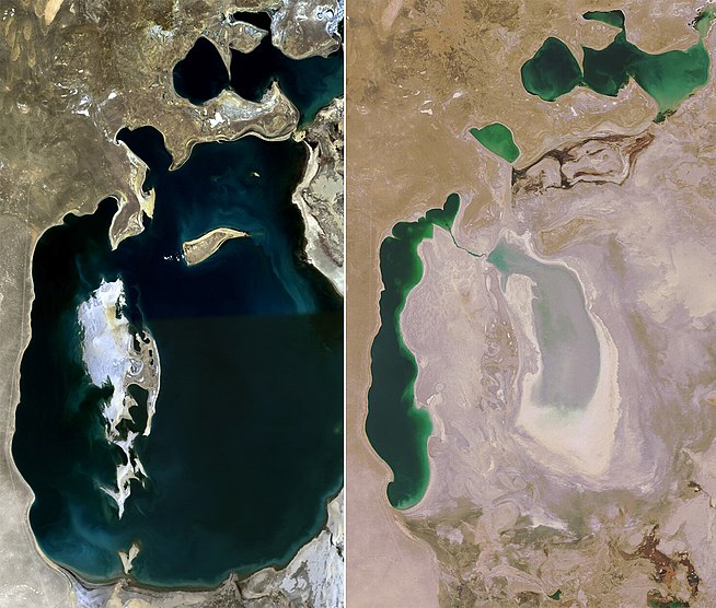
 Citiraj: The size of the Aral Sea has long hinged on the Amu Darya, which flows from the high Pamir Mountains in central Asia, across the desert, and into the southern sea. While two rivers empty into the lake—the Amu Darya and the Syr Darya—the Amu Darya is the largest and most fickle source of water. At times in ancient history, the river has bent its course to empty into the Caspian Sea, and the abandoned Aral Sea shrank. The Aral Sea has been at its largest when the Amu Darya feeds it.
Modern trends are no exception: when water began to be diverted from the Amu Darya for vast agricultural projects starting in 1960, the Aral Sea began to shrink. This image, taken on August 26, 2010, by the Moderate Resolution Imaging Spectroradiometer (MODIS) on NASA’s Terra satellite, demonstrates the close connection between the Aral Sea and the Amu Darya River. It is the most recent image in a ten-year sequence published on the Earth Observatory’s World of Change: Shrinking Aral Sea. Between 2000 and 2009, the Aral Sea steadily shrank. In 2006, severe drought settled in over Amu Darya Basin. Very little water reached the Aral Sea in 2007, and nothing flowed from the Amu Darya to the Aral Sea in 2008 and 2009, says Philip Micklin, a geographer from Western Michigan University who has been monitoring the Aral Sea for many years. Without water from the Amu Darya, the southern Aral Sea rapidly dwindled, the eastern lobe all but disappearing in 2009. In 2010, however, the drought broke. Snow in the Pamir Mountains was normal, and enough water flowed into the Amu Darya that the river reached the Aral Sea. The muddy pulse of water settled in a shallow layer over the bed of the eastern lobe of the South Aral Sea, making it look much larger that it had in 2009. Before 1960, the Aral Sea was the fourth largest lake in the world. However, much of the Amu Darya and Syr Darya have been diverted for agriculture, limiting the flow of water into the sea. Since 1960, the Aral Sea has lost 88 percent of its surface area and 92 percent of its water volume, says Micklin. |
|
| Stranica 1 od 1 | Sva vremena su u UTC [ DST ] |
| Powered by phpBB® Forum Software © phpBB Group http://www.phpbb.com/ |
|